Earthquakes May Explain Summerville Light’s Eerie Glow
1 February 2025 at 05:00
A seismologist thinks natural phenomena could explain the Summerville Light and other mysteries around a South Carolina locale.
A magnitude 3.8 earthquake off the coast of Maine shook parts of the Northeast on Monday morning, with residents as far away as Boston feeling the rumble, officials said.
The quake occurred about 6.5 miles southeast of York, Maine, just before 10:30 a.m., according to the U.S. Geological Survey (USGS), which initially reported the magnitude as 4.1 before adjusting the temblor to 3.8.
"Today's M3.8 near Bar Harbor, Maine, reminds us that earthquakes are unusual but not unheard of along the Atlantic Seaboard," USGS wrote on X.
The National Weather Service (NWS) in Caribou, Maine, said there was no threat of a tsunami.
TIPS FOR SURVIVING AN EARTHQUAKE AND PREPARING IN ADVANCE
There were no immediate reports of damage or injuries.
Residents in the Northeast reported feeling the surprise shock on social media.
"Earthquake! Did anyone else feel it?? I'm in Southern Maine and the whole house shook like a vehicle ran into it," one user wrote on X.
TRUMP'S VISIT TO SMALL-TOWN NORTH CAROLINA BRINGS HOPE TO HURRICANE SURVIVORS WHO LOST EVERYTHING
"Pretty decent jolt here. Big WTF moment," the user wrote in a second post. "I rushed to the windows to see if something hit the house."
NWS Boston, about 65 miles south of York, asked residents if they felt the rumble.
Other residents in New Hampshire and Rhode Island also reported the rattle.
USGS said that New England, and as far south as Long Island, N.Y., have felt small earthquakes and suffered damage from infrequent larger ones since colonial times.
"Moderately damaging earthquakes strike somewhere in the region every few decades, and smaller earthquakes are felt roughly twice a year," USGS said. "The Boston area was damaged three times within 28 years in the middle 1700's, and New York City was damaged in 1737 and 1884."
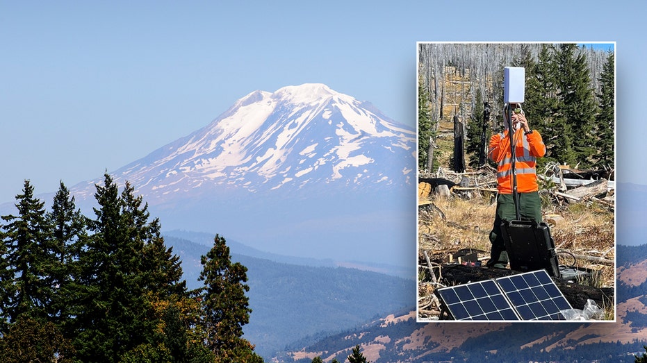
Scientists are deploying monitors at the volcanic Mount Adams in Washington State, after a spike in seismic activity.
The U.S. Geological Survey (USGS) said Mount Adams typically experiences an earthquake every two to three years, but in September, there were six earthquakes alone, marking the most in a single month since monitoring began in 1982.
The earthquakes were monitored by the USGS Cascades Volcano Observatory (CVO) and Pacific Northwest Seismic Network (PNSN) and ranged in magnitudes from 0.9 to 2.0. None of the earthquakes were felt at the surface, the USGS said.
With only one seismic station near the volcano, the USGS said monitoring capabilities are limited.
LAVA CONTINUES FLOWING FROM ICELAND VOLCANO AFTER ERUPTION
CVO and PNSN plan to install temporary seismic stations near Mount Adams to help detect smaller earthquakes while acquiring better estimates of size, location and depth. The data will help scientists assess the significance of the increased seismic activity near the volcano.
With permission from the U.S. Forest Service, CVO will place the temporary stations south and southwest of Mount Adams. Once activated, the data will be transmitted to CVO and PNSN in real-time.
LATEST ICELAND VOLCANIC ERUPTION SUBSIDES, BUT EXPERTS WARY OF MORE SOON TO COME
Despite the spike in seismic activity, the USGS says there is no indication that there is cause for concern and the alert level and color code for Mount Adams remains at Green and Normal.
Mount Adams is located in south central Washington, nearly 50 miles west-southwest of Yakima, Washington.
INDONESIA'S RUANG VOLCANO SPITS MORE HOT ASH AFTER ERUPTION FORCES SCHOOLS AND AIRPORTS TO CLOSE
In the north-south trending Mount Adams-King Mountain volcanic field of over 120 smaller volcanos, Mount Adams is the most prominent summit. It is also the second-tallest volcano in Washington and is the state's largest active volcano in volume and area, according to the USGS.
The agency said over the past 12,000 years, there have been four lava flows that started on the apron of the volcano and two vents along the south ridge. The flows have typically only traveled a few miles from their vents.
7.1 MAGNITUDE EARTHQUAKE STRIKES OFF JAPAN'S COAST, TSUNAMI ADVISORY ISSUED
The last time Mount Adams erupted was between 3,800 and 7,600 years ago, the USGS added.
But one of the biggest threats to people who live near the volcano are lahars, or muddy flows of rock, ash and ice that rush downstream like fast flowing concrete.
The summit, which is covered in ice, also covers up large volumes of hydrothermally weakened rock, which, if weakened by future landslides, could generate lahars.
![]()